Tiverton Eastern Urban Extension - Area B
Mid Devon District Council and Westcountry Land
Public Consultation - November & December 2024

Mid Devon District Council and Westcountry Land
Public Consultation - November & December 2024
The previous iteration of the Area B masterplan from the 2020 Public Consultation is shown here. It showed a network of streets provided across Area B which formed natural extensions to those provided within the adjacent Area A.
Fig.9. Street Typologies prepared for Consultation in 2020
Key masterplan principles for these routes and connections include:
These principles have been carried forward and evolved for this new consultation.
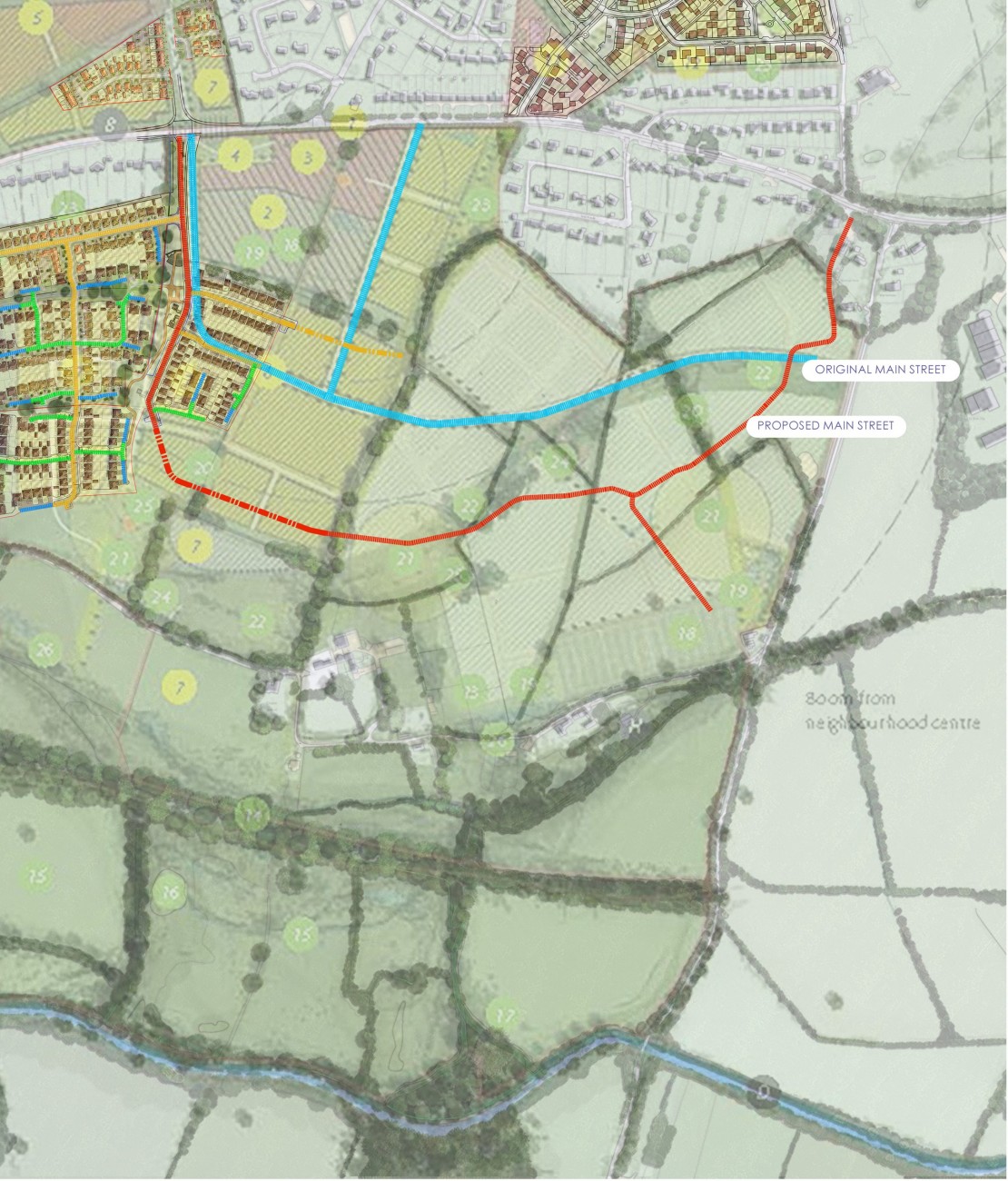
The previous consultation established the principle of a main street. This consultation loops the main street through the whole garden neighbourhood and back up onto Post Hill.
This change will introduce greater vibrancy to the street character, enabling public transport to pass efficiently though the entire site. It also presents an opportunity to reflect more closely the character of the surrounding settlements.
The underlying topography of Area B has been carefully considered to ensure that this Main Street would flow though the site working with the slopes and existing landscape features with opportunity to create a characterful main street; reinforcing a sense of place.
Existing planning consents and their street alignments as well as possible future connections to Area B have been taken into account.

Fig.10. Proposed Main Street Typology
The Adopted Masterplan SPD provides for two connection points from Area B on to Blundell’s Road via Area A.
An opportunity has arisen for an additional vehicular connection via Post Hill.
This provides the opportunity for the primary vehicular access into Area B to be taken off the northern edge of Area B from Post Hill with the secondary point of access coming via the western edge of Area B via Area A.
The two connections into Area A via Blundell’s Road would be retained.
Key aspects of the new junction arrangement are:
Fig.11. Proposed Access Junction onto Post Hill
Questions:
What are your thoughts about a new junction on Post Hill?
What do you think about a junction that gives priority to traffic from Area B over traffic using Blundell’s Road?
Please use the above to provide quick feedback on the question. You are also encouraged to provide more detailed written feedback on all the matters raised by using the feedback form available on our feedback tab (click to open).
A network of streets will be provided across Area B which form natural extensions to those provided within the developing adjacent Area A.
Key masterplan principles for these routes and connections include:
Question:
What are your thoughts about ‘up to 10 new homes’ having vehicular access off Mayfair?
Please use the above to provide quick feedback on the question. You are also encouraged to provide more detailed written feedback on all the matters raised by using the feedback form available on our feedback tab (click to open).
Fig.12. Proposed movement structure and street typologies
As part of the design process, the movement framework around, across and through the site has been carefully considered.
The evolving framework creates routes between parcels and the neighbourhood centre in Area A, and to the wider countryside and recreational facilities of Area B. The alignment of these routes differs from the wider looping main street. This offers opportunities to add characterful and memorable routes - place driven routes and spaces.
As the masterplan is evolving, and in line with the Design Guide, inspiration is been derived from the positive aspects of the surrounding settlements.
One inspiration is Village style streets - linked organic places, attractive character buildings around pockets of open space, naturally aligned green corridors and slow traffic routes.