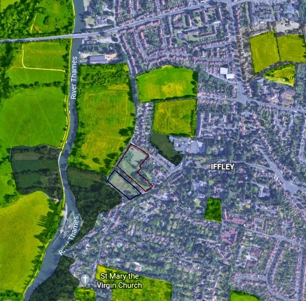
The Site
The site covers an area of approximately 1 hectare and is located on the western edge of Iffley Village, off Meadow Lane and Church Way. The site has most recently been used as paddocks/grazing land.
The site acquired by OX Place comprises two adjoining areas:
- The northern part of the site allocated in the Local Plan, on which the homes would be developed.
- The southern parcel (Memorial Field) which is not included in the Local Plan and will not be developed.
The site sits just 2.7 km south of Oxford City Centre, and is well connected to sustainable transport, which includes the Oxford City Cycle route and a nearby bus service on Henley Avenue serviced by three local services with connections to Oxford railway station, Rose Hill and Cowley, making it a suitable and sustainable location for development.
Interactive map showing site location
Policy context
The land has been allocated for development by Oxford City Council, as part of Policy SP42 of its Local Plan 2036, (adopted in 2020), with the allocation allowing for at least 29 homes to be built on the site.
The site is also located within the Iffley Conservation Area as identified in the Local Plan 2036, therefore any development of the site would have to conserve and enhance the unique characteristics of Iffley and consider the nearby Iffley Fields Site of Special Scientific Interest (SSSI) and the need for sustainable site drainage.
Survey works
A number of ecological surveys and assessments have been undertaken to inform our proposals, including an Ecological Impact Assessment and Biodiversity Impact Assessment which were informed by a desk study and detailed habitat surveys, as well as surveys for great crested newt, bat, badger, reptiles and invertebrates. A conservation and heritage assessment and an architectural contextual study were also completed.
Ecology Surveys
As part of the wider contextual analysis of the site the team have undertaken extensive ecological surveys establishing the presence of a number of different species on site.
- An active main badger sett, comprising 31 active entrance holes, is located within the site. A comprehensive badger mitigation strategy has been devised.
- Habitats are suitable to support foraging bats, although no potential bat roosting habitat is present within the site. A sensitive lighting strategy will be implemented and artificial bat roosting habitats will be installed on new buildings and on retained trees.
- Great Crested Newt eDNA surveys confirmed that Great Crested Newt are absent from the site and from ponds within 250m of the site.
- Common amphibians are present within terrestrial habitats on site. Precautionary working measures will be implemented to minimise the risk of harm or injury to common amphibians.
- Habitats within the site have potential to support nesting birds. Precautionary working measures will be implemented during site clearance. Bird boxes will be installed on new buildings and retained trees.
- Invertebrate surveys assessed the site as holding County value for invertebrates. Mitigation measures will be implemented within the site and the adjacent Memorial Field to mitigate the impacts on invertebrates.
- One common lizard was identified within the site during the reptile surveys. Precautionary working measures will be implemented during site clearance. Mitigation measures will be implemented within the site and the adjacent Memorial Field to mitigate the impacts on reptiles.
- Suitable habitat for hedgehogs is present on site. Precautionary working measures will be implemented during site clearance.
- Japanese knotweed, an invasive plant species listed on Schedule 9 of the Wildlife and Countryside Act 1981, was identified within the site. An invasive species management plan will be implemented.
The results of these ecological surveys have helped to inform our proposals by ensuring the development is designed to reflect key ecological features.
